Using Geospatial Intelligence for Emergency Response
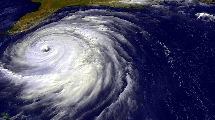
Image courtesy of kakela under Attribution-NonCommercial-NoDerivs 2.0 Generic License, resized to 700 x 391 pixels.
Forget about artificial intelligence, from an emergency preparedness perspective, geospatial intelligence is far more relevant. Geospatial intelligence involves the development of real-time maps based on data points aggregated from satellites, sensors, drone imagery, and similar technologies. The resulting maps help predict when and where a threat may emerge, and how severe it may be.
Specific Use Cases for Geospatial Intelligence
Although geospatial intelligence is primarily employed by government agencies to improve the safety of communities, utilities may want to start paying attention. The technology is currently being utilized for purposes before, during, and after an event.
Before and during the event, weather patterns such as storm location, trajectory, wind speeds, and similar metrics can be compiled and mapped to help guide storm warnings and evacuation orders. The National Hurricane Center currently employs this approach.
After an event, geospatial intelligence is often used for search and rescue operations. This was done in Feb. 2023 after an earthquake hit Turkey and Syria – maps and arial images were used to immediately identify the extent of damage as well as the most treacherous and hard-hit areas, right down to the neighborhood level.
From a “blue sky” perspective, the technology offers comprehensive monitoring capabilities to help track global climate trends. This helps, for example, identify areas that may be at an elevated risk of heat waves and wildfires, which in turn helps prioritize emergency preparedness activities. The technology can also play a role in military operations. Really, the sky’s the limit.
In the final analysis, geospatial intelligence is currently more of a government tool than a utility tool, but that doesn’t mean utility companies don’t see residual benefits – as they say, a rising tide raises all boats. Going forward, I predict that more and more utilities will find a way to tap into geospatial intelligence, whether it’s to leverage existing government tools or to develop custom solutions. This may be decades away, but sooner or later, it will become a reality.